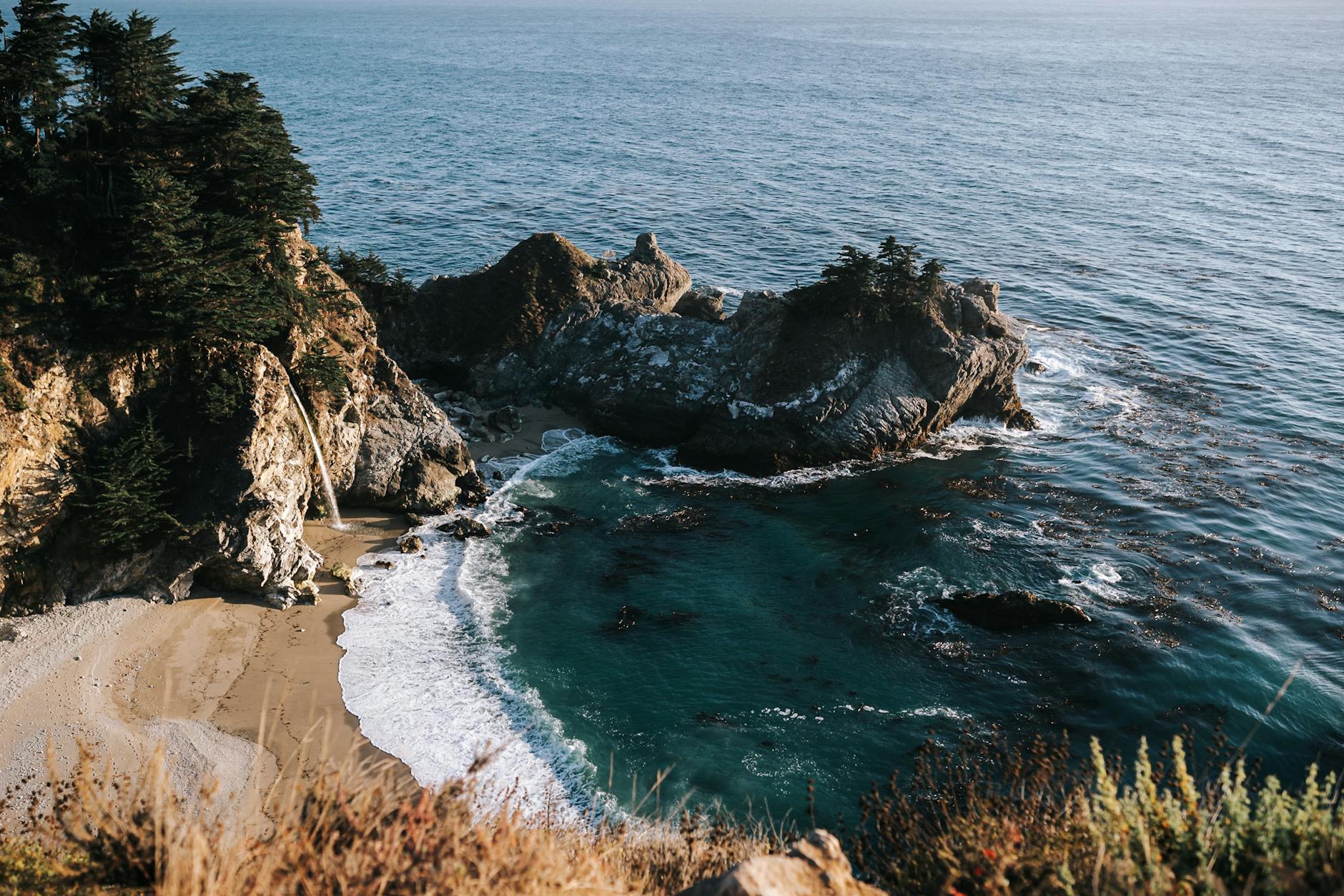
Big Sur & the California Coast: A Nature Travel Guide
🌍 Plan & Book Your Trip
Compare the best deals for this destination — flights, hotels, tours and more:
Affiliate links — we may earn a commission at no extra cost to you.
Highway 1 threading along the cliffs of Big Sur — one of the most beautiful drives on earth.
There’s a stretch of California where the continent simply runs out — where redwood forests tumble down to crashing surf, waterfalls drop straight onto the beach, and a two-lane highway clings to cliffs hundreds of feet above the Pacific. This Big Sur travel guide is your roadmap to that stretch: roughly 90 miles of Highway 1 between Carmel and San Simeon that ranks among the most jaw-dropping coastal drives on the planet.
Big Sur isn’t a town so much as a region and a feeling — rugged, remote, and gloriously undeveloped. There are no big resorts or chain stores, just turnouts, trailheads, and views that make you pull over again and again. In this guide I’ll cover the must-see stops (McWay Falls, Bixby Bridge, Pfeiffer Beach), the redwoods, where to stay and eat, and the single most important thing: when to go and how to handle Highway 1’s notorious closures.
Key Takeaways
- Big Sur is a Highway 1 road trip, not a single destination — the drive is the attraction.
- Don’t miss McWay Falls (a waterfall onto the beach), Bixby Bridge, and Pfeiffer Beach (purple sand, Keyhole Rock).
- Redwoods meet the ocean here — Pfeiffer Big Sur and Julia Pfeiffer Burns State Parks are the highlights.
- Check Highway 1 status before you go — landslides occasionally close sections for extended periods.
- Book lodging and camping far in advance; options are limited and pricey, and there’s almost no cell service.
Quick Facts
| 📍 Location | Central California coast (Carmel to San Simeon) |
|---|---|
| 🛣️ The drive | ~90 miles of Highway 1 |
| ⏱️ Ideal time | 2–3 days (don’t rush it) |
| 🗓️ Best season | September–November (clear skies, fewer crowds) |
| 🌊 Famous for | McWay Falls, Bixby Bridge, redwoods, cliffs |
| 📵 Heads up | Little to no cell service; limited gas & lodging |
The #1 planning tip: Highway 1 through Big Sur is prone to landslide closures. A section can be shut for months. Always check the current road status (Caltrans) before your trip and have a backup plan — sometimes you access Big Sur from only one direction.
How to Get There
Gateways:
- From the north: Most people start in Monterey/Carmel, accessible from San Francisco (about 2 hours to Carmel) or San Jose.
- From the south: San Simeon/Cambria (near Hearst Castle), reachable from Los Angeles (about 3.5–4 hours).
Getting around: You need a car, full stop. There’s no public transit through Big Sur. Drive the iconic Highway 1 slowly, pulling off at the many turnouts. Fill up your gas tank before you enter — fuel in Big Sur is scarce and expensive — and download maps offline, because cell service essentially disappears.
How to Plan the Drive
Most people drive Big Sur as a one-way leg of a larger California coast road trip (San Francisco to Los Angeles or vice versa) or as an out-and-back from Carmel. Here’s the orientation:
| Direction | Pro | Con |
|---|---|---|
| North → South | Ocean on your right (passenger side) | Pull-offs require crossing traffic |
| South → North | Pull-offs on your side (easier stops) | Sun glare in afternoon |
The Best Stops in Big Sur (North to South)
1. Bixby Creek Bridge
The most photographed spot in Big Sur, and for good reason — a graceful concrete arch spanning a deep canyon with the ocean beyond. There’s a turnout on the north side for the classic shot. Arrive early; it gets busy and parking is tight.
2. Point Sur & Andrew Molera State Park
A historic lighthouse perched on a volcanic rock, plus a state park with beach and bluff trails. Andrew Molera offers some of the best easy coastal hiking in the region.
3. Pfeiffer Big Sur State Park (Redwoods)
This is where you walk among coast redwoods in the Big Sur River valley. Gentle trails like the Pfeiffer Falls loop wind through towering trees — a cool, green contrast to the sun-blasted cliffs. A great spot for families and a base for camping.
4. Pfeiffer Beach (Purple Sand & Keyhole Rock)
Down a narrow, unmarked road (easy to miss — watch your map): a stunning beach famous for the Keyhole Rock, where at sunset in winter the light beams through the arch. The sand has a purple tint from manganese garnet in the cliffs. Note the small parking lot and day-use fee.
5. Julia Pfeiffer Burns State Park & McWay Falls
The crown jewel. A short, easy walk from the parking area leads to an overlook of McWay Falls — an 80-foot waterfall that drops directly onto a pristine, inaccessible cove beach. It’s one of the only “tidefall” waterfalls in California and pure magic at golden hour. (You can’t go down to the beach — enjoy it from the overlook.)
6. Partington Cove & Big Sur Coast Highlights
A short, steep trail to a rocky cove and an old tunnel, plus countless unnamed turnouts where you can simply stand and watch the surf hammer the cliffs.
7. Sand Dollar Beach & Jade Cove (South Big Sur)
Toward the southern end, wider beaches and the famous Jade Cove, where rockhounds hunt for Big Sur jade. The crowds thin out down here.
8. Elephant Seal Rookery (San Simeon)
Near the southern gateway, pull over to watch hundreds of elephant seals lounging and sparring on the beach — a wild, free, and genuinely fascinating stop, especially in winter and spring.
The Best Short Hikes
| Hike | Park | Distance | Why Go |
|---|---|---|---|
| McWay Falls Overlook | Julia Pfeiffer Burns | ~0.6 mi | The iconic beach waterfall |
| Pfeiffer Falls Loop | Pfeiffer Big Sur | ~2 mi | Walk among the redwoods |
| Bluffs / Headlands (Andrew Molera) | Andrew Molera | ~2–8 mi | Big coastal views |
| Partington Cove | Big Sur coast | ~1 mi | Hidden cove + tunnel |
| Buzzards Roost | Pfeiffer Big Sur | ~3 mi | Forest climb to a ridge view |
| Ewoldsen Trail | Julia Pfeiffer Burns | ~4.5 mi | Redwoods + ocean overlook |
Best Time to Visit
Fall (September–November): The local secret. Summer fog clears, skies are blue, temperatures are mild, and the summer crowds thin out. This is the best time to visit Big Sur.
Spring (March–May): Green hillsides, wildflowers, and full waterfalls. Lovely, with moderate crowds. Some lingering rain.
Summer (June–August): Peak crowds and notorious coastal fog (“May gray” and “June gloom” can extend into summer). It’s still beautiful, but the marine layer often hides the views until afternoon — and traffic and lodging prices peak.
Winter (December–February): Dramatic and moody, with the chance of storms and the famous Keyhole Rock sunset at Pfeiffer Beach. Fewer people, but a higher risk of road closures from landslides and rain.
The sweet spot: September and October for clear skies, warm-ish weather, and thinner crowds. Visit Pfeiffer Beach near sunset in December–January if you want that beam-through-the-arch shot.
Where to Stay
Big Sur lodging is limited, rustic-to-luxurious, and books out far ahead:
- Camping: Pfeiffer Big Sur State Park, and various private campgrounds (Big Sur Campground, Riverside) — reserve early.
- Mid-range to lodge: Big Sur Lodge (in the state park), Glen Oaks, Ripplewood, and Fernwood.
- Luxury: Iconic clifftop resorts like Post Ranch Inn and Ventana (splurge territory).
- Gateway towns: Stay in Carmel/Monterey (north) or Cambria/San Simeon (south) for more options and lower prices, then day-trip in.
Reserve everything early. Big Sur has few rooms and campsites, and they fill months ahead in peak season.
What to Pack
- Layers — it can swing from foggy and cold to sunny and warm in an hour
- A windbreaker — the coast is breezy, especially at overlooks
- Sturdy shoes — for redwood and bluff trails
- A full tank of gas — and don’t let it drop low
- Snacks and water — services are sparse and pricey
- Offline maps — there’s essentially no cell service
- A real camera or charged phone — you’ll use it constantly
- Cash — handy for some small vendors and parking
A Quick Reflection
I’d built up McWay Falls so much in my head that I half-expected to be disappointed. I’d seen the photo a hundred times — the waterfall, the turquoise cove, the impossibly perfect beach you can’t reach. Surely the real thing couldn’t compete.
I walked the short path with a crowd of other people, all of us a little jaded, phones already out. Then we rounded the bend and the whole cove opened up below — the falls catching the late afternoon light, the surf glowing aquamarine, the whole scene framed by cliffs. The chatter just… stopped. A dozen strangers fell quiet at the same moment, and we all stood there grinning like idiots.
What I remember most isn’t the waterfall, though. It’s what happened after, when I pulled into a random unnamed turnout a few miles down the road, completely alone, and watched the sun melt into the Pacific with no one else around. No name, no sign, no crowd. Just me and the edge of the continent. That’s the real Big Sur — the famous stops are worth it, but the magic lives in the spaces between them.
Practical Tips & Mistakes to Avoid
- Check Highway 1 status first. Landslides can close sections for months — confirm with Caltrans and have a backup plan.
- Fill up on gas. Fuel is scarce and expensive in Big Sur; never enter on a low tank.
- Go slow and budget time. The mileage is short but you’ll stop constantly. Don’t try to “pass through” in a rush.
- Download maps offline. Cell service is almost nonexistent.
- Book lodging months ahead. Rooms and campsites are few and sell out.
- Arrive early at popular stops (Bixby, McWay) — parking is tiny and fills fast.
- Respect closures and stay back from cliff edges. They’re unstable, and rescues are difficult.
Suggested 2-Day Itinerary
Day 1 — North Big Sur: Start in Carmel, stop at Bixby Bridge, explore Andrew Molera bluffs, walk the redwoods at Pfeiffer Big Sur, and end with Pfeiffer Beach at sunset.
Day 2 — South Big Sur: Visit McWay Falls in the morning light, hike the Ewoldsen Trail, browse Jade Cove, and finish at the elephant seal rookery near San Simeon (with an optional Hearst Castle visit).
FAQ
What is the best time of year to visit Big Sur? September through November is the sweet spot — summer fog clears, skies are blue, temperatures are mild, and the crowds thin out. Spring brings green hills and waterfalls, while winter offers dramatic skies (and the Pfeiffer Beach Keyhole sunset) but a higher risk of road closures.
How many days do you need in Big Sur? Two to three days lets you enjoy the drive without rushing — one day for the northern stops and redwoods, one for McWay Falls and the southern coast. You can drive through in a single long day, but you’ll regret not lingering.
Can you see McWay Falls up close, and is it free? You view McWay Falls from a short, easy overlook trail in Julia Pfeiffer Burns State Park — you can’t walk down to the beach (it’s protected and inaccessible). There’s a state park day-use parking fee, but the falls themselves are well worth it.
Is Highway 1 through Big Sur open right now? It depends — Big Sur’s Highway 1 is prone to landslide closures that can last months. Always check the current Caltrans road status before your trip. Sometimes Big Sur is only accessible from one direction (north or south) at a time, so plan your route accordingly.
Road and park conditions change frequently in Big Sur. Verify Highway 1 status with Caltrans and check state park hours and fees at parks.ca.gov before you go.
Before you go, check road and park conditions on the official California State Parks site (Big Sur’s parks and Highway 1 close at times).
Final Thoughts
Big Sur is less a checklist and more a state of mind — the kind of place where the drive between the famous stops is just as memorable as the stops themselves. Take Highway 1 slowly, fill your tank, book your bed early, and time your visit for that golden fall window when the fog lifts and the coast glows. Stand at the McWay Falls overlook, pull off at a nameless turnout to watch the sun sink into the Pacific, and you’ll understand why this ribbon of California coast has captivated travelers, writers, and dreamers for generations.
Chasing more West Coast beauty? See the Best Photo Spots in Yosemite, the Best Sunrise Hikes in the USA, and our roundup of the 12 Best Hikes Near Los Angeles. Map your California coast road trip with our free Trip Planner.
FAQ Schema (paste in a Custom HTML block at the end of the post)
“html “
✈️ Planning your trip?
Compare cheap flights, hotels and car rentals for your adventure.
Find Cheap Flights →Compare Hotels →🌍 Plan & Book Your Trip
Compare the best deals for this destination — flights, hotels, tours and more:
Affiliate links — we may earn a commission at no extra cost to you.


